Monday, September 27, 2010

Sunday, September 26, 2010
Still Riding
Now in Argentina
I must say the road conditions are much better.
View Larger Map
 Still heading south. Weather has been great and we are leaving Tupiza Argentina.
I must say the road conditions are much better.
View Larger Map

Sunday, September 19, 2010
UYUNI
Still on the road. Today we are in Uyuni, on the edge of the great Salar de Uyuni (or Salar de Tunupa). This is the world's largest salt flat at 4,086 sq miles. It is located in southwest Bolivia, near the crest of the Andes. It's elevation is almost 12,000 ft above sea level. The Salar was formed as a result of transformations between several prehistoric lakes. It is covered by a few meters of salt crust. The crust serves as a source of salt and covers a pool of brine, which is exceptionally rich in lithium. It contains 50 to 70% of the world's lithium reserves, which has yet to be extracted. The large area, clear skies and exceptional surface flatness make the Salar an ideal object for calibrating the altimeters of the Earth observation satellites. The Salar serves as the major transport route across the Bolivian Altiplano and is a major breeding ground for several species of pink flamingos.
You can see the salt flat on the map above. It's the large white area. Over 4,000 sq miles it is easily identified from the air.


 |
| Narcotics stops and various other opportunities for stops and searches are all over the roads. |
Thursday, September 16, 2010
DAY 4 - Still in LA PAZ
LA PAZ BOLIVIA
We've explored LA PAZ, on foot, by car and now by motorcycles. This is some of the most beautiful scenery I've ever taken in. However; the road travel is harsh. Here's a shot of the road conditions, check out the jagged edges on the rocks.

Those rocky conditions took their toll on Keith's tire which went flat during our venture out. Unfortunately, it took this gringo a long time to find a pump given my lack of bien espanol, that we ended up on the Death Road back to LA PAZ at dark. I don't recommend this.
Because of the extreme dropoffs, single-lane width, and lack of guardrails, the road is extremely dangerous. Lack of light and depth perception add to the danger. Further still, rain and fog can make visibility precarious, the road surface muddy, and loosen rocks from the hillsides above.
In 1995 the Inter-American Development Bank christened it as the "world's most dangerous road". One estimate is that 200-300 travelers are killed yearly along the road, or one vehicle every two weeks. The road moreover includes crosses marking the spots where vehicles have fallen.
Upon leaving La Paz, the road first ascends up to around 5km, before descending to 1079 ft (330 m), transitioning quickly from cool altiplano terrain to rain forest as it winds through very steep hillsides and atop cliffs.
The road was built in the 1930s during the Chaco War by Paraguayan prisoners. The road connects the Amazon rainforest region of northern Bolivia, or Yungas, to its capital city.
.jpg)
The good news is, when we returned to the hotel, dinner was served. We didn't realized when you order Lamb for dinner, they bring the whole leg! Look at this slab of meat!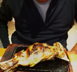

Tomorrow we head off to Potosi, about 300 miles.
This could take a while........
Check back for more updates shortly! Thanks for visiting!!
Tuesday, September 14, 2010
LA PAZ BOLIVIA
Day 1 and Day 2! We have arrived. We came in a few days early to adjust to the altitude. La Paz is known as the city that touches the sky, is an apt description. Located high above sea level, La Paz sits in a bowl surrounded by the high altiplano. La Paz as it grows climbs the hills resulting in varying elevations from 3000 to 4100 m. Overlooking the city is towering triple-peaked Illimani, always snow covered and majestic. The famous road to get here is known as the El Camino del Muerte or The Road of Death! Yesterday we drove the road in a cab with our driver. Tomorrow, we set out on motorcycles to conquer the road on our own. I apologize if the blog posts are slow, the internet and download capabilities are slow, but I will do my best!


Friday, September 10, 2010
PACKING BEGINS
I am packing now for the trip to South America. I will journey down via Airplane to LaPaz,Boliva and begin the trip on September 12th. The first 23 days are a guided tour with Compass. After that, just me and a good buddy will travel down to Tierra Del Fuego. Check back on a regular basis for photos and updates on my journey. I will try to keep the posts coming. Look for me on ADV rider as well - VTBeemer! Cheers!

Subscribe to:
Posts (Atom)